Overview
Crop identification and acreage estimation: Estimates are required end-of-season. Early in-season estimates for winter crops (winter wheat and rapeseed) are desirable.
Crop biophysical variables (LAI, fCover, biomass). LAI estimates are going to be assimilated into semi-empirical local yield models. It is desirable to have estimates on a weekly basis through the whole growing season.
Yield Prediction and Forecasting
The mapping resolution is 5-10 m for field level estimates and is 30-60 m for regional mapping. The timeliness of the data is with regards to growing season. Field data can be delivered two weeks after acquisitions. Partial data analysis will be done at the end of growing season.
Project Objectives
Mapping Agricultural Areas
Operational Implementation Plan
Scale
The mapping resolution is 5-10 m for field level estimates and is 30-60 m for regional mapping
Land Cover
- Spatial Resolution:
- Temporal Resolution:
Estimating Crop Area
Operational Implementation Plan
Field size measurement
Estimation of Biophysical Variables
Operational Implementation Plan
Biophysical Variables
- LAI (Leaf Area Index)
- Biomass
- fCover
Forecasting Agricultural Variables
Operational Implementation Plan
Agricultural Variables (large scale)
Site Description
| Landscape Topography | Mostly flat with slopes ranging from 0% to 2%. Near 10% of the territory is hilly with slopes about 2-5%. |
|---|
| Typical Field Size | 30-250 ha. |
|---|
| Climatic Zone | Temperate, cold |
|---|
| Major Crops and Calendars | Winter rapeseed (Normal):
Typical Rotation: Due to relatively large number of major crops and other factors there is no a typical simple crop rotation in this region. Most producers use different crop rotations depending on specialization.
Winter Wheat (Normal):
Typical Rotation: Due to relatively large number of major crops and other factors there is no a typical simple crop rotation in this region. Most producers use different crop rotations depending on specialization.
Spring Barley (Normal):
Typical Rotation: Due to relatively large number of major crops and other factors there is no a typical simple crop rotation in this region. Most producers use different crop rotations depending on specialization.
Maize:
Typical Rotation: Due to relatively large number of major crops and other factors there is no a typical simple crop rotation in this region. Most producers use different crop rotations depending on specialization.
Soya beans:
Typical Rotation: Due to relatively large number of major crops and other factors there is no a typical simple crop rotation in this region. Most producers use different crop rotations depending on specialization.
Sunflower:
Typical Rotation: Due to relatively large number of major crops and other factors there is no a typical simple crop rotation in this region. Most producers use different crop rotations depending on specialization.
Sugar beet:
Typical Rotation: Due to relatively large number of major crops and other factors there is no a typical simple crop rotation in this region. Most producers use different crop rotations depending on specialization.
Other vegetables:
Typical Rotation: Due to relatively large number of major crops and other factors there is no a typical simple crop rotation in this region. Most producers use different crop rotations depending on specialization.
|
|---|
| Soil Type & Texture | Organic: |
|---|
| Soil Drainage Class | ["Well drained","Moderately well drained","Imperfectly drained","Poorly drained"] |
|---|
| Irrigation Infrastructure | ["Surface irrigation"] |
|---|
| Other Site Details | The site consists of two parts:
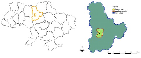
- the whole Kyiv region (28,000 sq. km) indented for crop mapping and acreage estimation (Fig. 1-a);
- intensive observation sub-site (25×15 sq. km) indented for crop biophysical parameters estimation (Fig. 1-b). This sub-site consists of research farm of National University of Life and Environmental Sciences of Ukraine (NULESU) where intensive in-situ measurements are being collected.
The latitude and longitude of the site and sub-site are given in Table 1.

Figure 1. JECAM Test Sites Location. Kyiv region (a) and intensive observation sub-site – Vasilkov county (b)
|
|---|
In Situ Observations
Crop height
- Crop Type(s):
- Collection Protocol:
- Frequency: About two times for each crop per year.
Crop Type
Digital Hemispheric Photographs
- Crop Type(s):
- Collection Protocol:
Images were acquired with a NIKON D70 camera, hemispherical images acquired during the field campaign are processed with the CAN-EYE software (http://www.avignon.inra.fr/can_eye) to derive LAI, FAPAR and FCOVER
- Frequency:
EO Data
Optical Data Requirements
Approximate Start Date of Acquisition: 01/04
Approximate End Date of Acquisition: 01/10
Spatial resolution: Medium resolution (20-60m)High resolution (5-20m)
temporal_frequency: Biweekly
Level of Expertise: Intermediate
Latency of Data Delivery:
Challanges:
SAR Data Requirements
Approximate Start Date of Acquisition: 01/04
Approximate End Date of Acquisition: 01/10
Spatial resolution: Medium resolution (20-60m)High resolution (5-20m)
temporal_frequency: Biweekly
Frequency: XCL
Incidence Angle: Medium
Polarisation:
Level of Processing: Level 2
Orbit: Any
Level of Expertise: Intermediate
Latency of Data Delivery: More than 5 days
Challanges:
Passive Microwave Data Requirements
Thermal Data Requirements
Results
Documents and Files
Links to paper
Project Reports
Study Team
Team Leader
Name: Natalia Kussul
Affiliation: Space Research Institute NASU-SSAU
Affiliation Webpage: http://www.nkau.gov.ua
Position: Deputy Director
Email: kussul@mail.ru
Personal Webpage:
Phone number:
Postal Address:
Other Team Members

