Overview
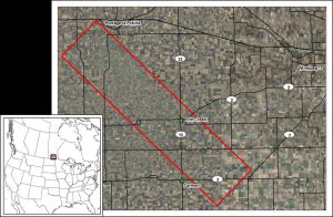
The study site is located in south central Manitoba, Canada. Land use is dominated by annual cropping. The soil texture varies greatly across the site with heavy clays in the east and loamy fine sands in the west. Agriculture and Agri-Food Canada (AAFC) has a permanent in situ soil moisture station network in the area (http://agriculture.canada.ca/SoilMonitoringStations/index-en.html). The site has been used extensively to develop and validate soil moisture retrievals using Canada’s RADARSAT satellites. Numerous remote sensing research studies have been conducted in this area which include crop mapping and condition monitoring, crop biophysical parameters (LAI, biomass) retrieval.
Project Objectives
Measuring Phenological Events
Phenological Events
- Seedling
- Vegetative Growth
- Flowering
- Fruit Development
- Maturity
Estimation of Biophysical Variables
Operational Implementation Plan
A new LAI estimation approach based on coupling of the Water Cloud Model and the Ulaby soil moisture model has been developed. The coupled model was calibrated and validated for two economically important crops, corn and soybeans, using the data collected during the Soil Moisture Active Passive Validation Experiment 2012 (SMAPVEX12). The estimated LAI from C-band (for corn and soybeans) and L-band (for Corn only) are comparable to errors reported using optical satellite sensors. This study is important in that it demonstrates the capability of SAR to estimate LAI, offering an important advantage for operational crop growth monitoring.
Biophysical Variables
- LAI (Leaf Area Index)
- Biomass
Soil moisture
Soil moisture retrival
Site Description
| Landscape Topography | almost flat, in the heart of a rich prairie agricultural belt. |
|---|---|
| Typical Field Size | nominal field size is 800 m by 800 m |
| Climatic Zone | Humid continental climate zone |
| Major Crops and Calendars | Canola (Normal): Spring Wheat (Normal): Soybean (Normal): Maize (Normal): |
| Soil Type & Texture | Inorganic:
|
| Soil Drainage Class | Array |
| Irrigation Infrastructure | Array |
| Other Site Details |
|
In Situ Observations
Phenology
- Crop Type(s): Maize, Canola, Spring Wheat, Soya beans
- Collection Protocol:
Crop phenology are observed using the BBCH scale during the entire growing season
- Frequency: Weekly
Soil Moisture
- Crop Type(s): Maize, Canola, Spring Wheat, Soya beans
- Collection Protocol:
Permanent in situ soil moisture network are installed in this site. The network consists of nine monitoring stations. At each station three Stevens Hydra probes have been placed at each of four depths – 5, 20, 50 and 100 cm. Each probe records soil moisture percentage (using Stephen’s default dielectric conversion model), soil temperature in Celsius and real soil dielectric permittivity.
- Frequency: Measurements are collected on a 30 minute time scale.
Surface Roughness
- Crop Type(s): Bare soil
- Collection Protocol:
Surface roughness was measured with a portable pin profilometer that uses surface displacement and post-processing techniques to obtain root mean square roughness (rms) and roughness correlation length (?). Roughness measurements must be taken over long profiles (typically several metres). To achieve a longer metre profile, once one profilometer measurement was taken, the instrument was moved such that the end of the first measurement became the start of the second measurement. This was repeated a second time to achieve a 3-metre profile comprised of three 1-metre profiles.
- Frequency: once a year
LAI
- Crop Type(s): Canola, Soybean, Spring Wheat, Maize
- Collection Protocol:
hemispherical digital photos
- Frequency: weekly
biomass and water content
- Crop Type(s): Canola, Soybean, Spring Wheat, Maize
- Collection Protocol:
destructive sampling
- Frequency: weekly
Crop height and stem diameter
- Crop Type(s): Canola, Soybean, Spring Wheat, Maize
- Collection Protocol:
10 height and diameter measurements were taken using a tape measure (height) or caliper (stem diameters).
- Frequency: weekly
EO Data
Optical Data Requirements
SAR Data Requirements
Passive Microwave Data Requirements
Thermal Data Requirements
Results
Documents and Files
GEO_JECAM_Canada_Red_River_Progress_Report_2014.pdf GEO_JECAM_RedRiver_Canada_Progress_Report_2015.pdfLinks to paper
Roy, S. 2014. Simulation of Spatial and Temporal Variability of Soil Moisture Using the Simultaneous Heat And Water (SHAW) Model: Applications to Passive Microwave Remote Sensing, Graduate Thesis, University of Guelph, Department of Geography.
Rowlandson, T. L., A. A. Berg, P. R. Bullock, E. R. Ojo, H. McNairn, G. Wiseman, and M. H. Cosh, 2013: Evaluation of several calibration procedures for a portable soil moisture sensor. Journal of Hydrology, 498, 335-344.
Project Reports
Study Team
Team Leader
Other Team Members

