Overview
The first aim of the OSR is to collect and organize in-situ and remotely-sensed data in order to serve pluridisciplinary research works on various environmental issues related to agriculture, biodiversity, water and carbon management.
The second aim of the OSR is to favor the development of tools and services for territories management through space technologies applications, falling within the framework of the “GMES downstream services”. To achieve this goal, partnerships are built between laboratories, end-users (eg. local authorities, decision makers) and private companies. These partnerships are based on the sharing of information.
- Crop identification and Crop Area Estimation
- Crop Condition/Stress
- Soil Moisture
- Yield Prediction and Forecasting
- Crop Residue, Tillage and Crop Cover Mapping
- CO2 and water fluxes/budgets
Project Objectives
Estimation of Biophysical Variables
Operational Implementation Plan
Over the experimental sites : Both Auradé and Lamasquère sites are ICOS sites and therefore biomass, soil humidity, meteorological, flux measurements are standardised following the ICOS protocols. See http://gaia.agraria.unitus.it/icos/working-groups
In total, 135 micro-meteorological variables are recorded every 30 minutes at each site. They include air temperature and humidity, air pressure, soil temperature and humidity at 0-5, 5, 10, 30, 100 cm depth, soil heat flux at 5 cm depth, global (shortwave and longwave) and PAR incident radiation, global (shortwave and longwave) and PAR reflected radiation, albedo, transmitted PAR, diffuse PAR and global shortwave radiation, NDVI, PRI, surface temperature, soil CO2 and N2O fluxes (automatic chambers), net CO2, water, sensible heat fluxes by means of the eddy-covariance method… Details concerning biomass, LAI and soil humidity measurements are presented in the Table 2 of Annex 1.
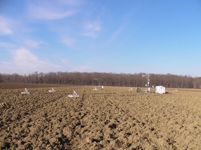
Figure 4: The Lamasquère site from around the micrometeorological station.
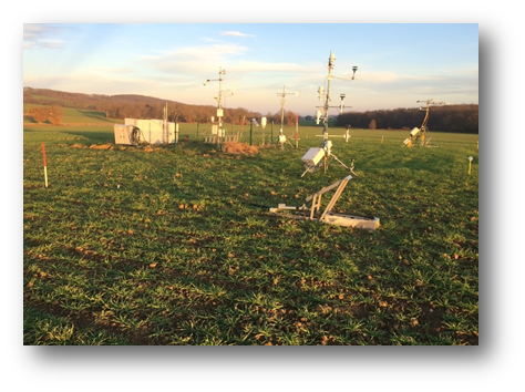
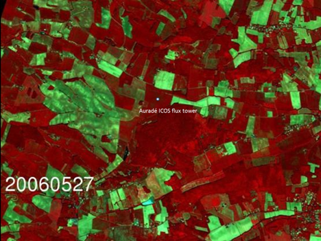
Figure 5: The Auradé site from around the micrometeorological station
Over the OSR area:
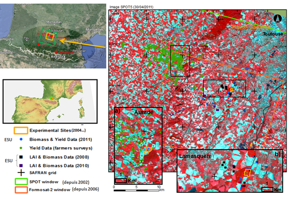
Additional measurements of LAI, biomass were performed over the OSR area. See Table 2 in Annex 1 for details. Also ground truth for Land Use were collected 4 times during the year on approximately 450 plots (see Figure 6).
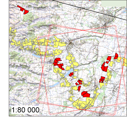
Figure 6: Lande use Monitoring campaigns have been carried since 2006 with approximately 450 plots monitored each year (see yellow and red fields on the map below) and up to 1500 in 2015.
Plans for Next Growing Season:
Next growing season, will you maintain your current approach, or modify the approach? If you plan to modify, please describe your new approach.
In the frame of the Sensagri and Bag’ages project (financed by the Adour Garonne Water Council), we plan to develop SAR data assimilation in our modelling approach of biomass, yield, C & water fluxes and budgets by using the SAFYE-CO2 model. We also plan to account for the effect of cover crops or crop regrowth on thoses fluxes and budgets.
Also in the frame of the Bag’ages project 9 micro-meteorological stations will be installed (see Figure 10), covering a soil (from very dark to clear) and climatic gradient from the south-west part of France till the Eastern Pyrenees. Those stations, installed on cropland with contrasted management, will allow us to monitor air/ sol surface temperature, air humidity, precipitations, soil water content profiles from surface to 1m deep, ETR, incoming/outgoing shortwave radiation (albedo), incoming/outgoing longwave radiations. Automatic cameras will be used to monitor daily crop phenology/soil status/crop management. Those measurements will be used to validate high resolution albedo GAI and SWC products (some of them being developed within the frame of SENSAGRI).
Finally, close to 1000 plots will be monitored 5 time a year to follow land cover (mainly on croplands) and crop management within the frame of the Sensagri project. Those data will be used for validation of dynamic high resolution land use maps.
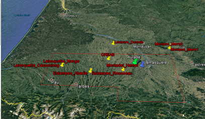
Figure 10: Location of the 9 micro-meteorological stations that will be installed on agricultural plots in the frame of the Bag’ages project and that will complete the OSR setup (Auradé & Lamaquère sites)
Biophysical Variables
- LAI (Leaf Area Index)
- Biomass
- Flux measurements
Forecasting Agricultural Variables
Operational Implementation Plan
Agricultural Variables (large scale)
- Soil Moisture
Site Description
| Landscape Topography | Hilly for Auradé, in a valley for Lamasquère |
|---|---|
| Typical Field Size | Approx. 30 ha at Auradé and 20 ha at Lamasquère |
| Climatic Zone | Temperate, cold |
| Major Crops and Calendars | Winter Wheat: Sunflower: Rapeseed: Maize: |
| Soil Type & Texture | Inorganic:
|
| Soil Drainage Class | |
| Irrigation Infrastructure | ["Surface irrigation","No irrigation (precipitation)"] |
| Other Site Details | Site includes 2 experimental plots (Auradé and Lamasquère Fluxnet/ICOS sites) Auradé only receives mineral fertilisers whereas Lamasquère receives both mineral and organic fertilisers. Lamasquère is irrigated when maize is grown. Irrigation at Lamasquère when maize is grown.
|
In Situ Observations
Biomass, soil humidity, meteorological, flux measurements
- Crop Type(s):
- Collection Protocol:
In total, 135 micro-meteorological variables are recorded every 30 minutes at each site. They include air temperature and humidity, air pressure, soil temperature and humidity at 0-5, 5, 10, 30, 100 cm depth, soil heat flux at 5 cm depth, global (shortwave and longwave) and PAR incident radiation, global (shortwave and longwave) and PAR reflected radiation, albedo, transmitted PAR, diffuse PAR and global shortwave radiation, NDVI, PRI, surface temperature, soil CO2 and N2O fluxes (automatic chambers), net CO2, water, sensible heat fluxes by means of the eddy-covariance method.
- Frequency:
LAI, biomass
- Crop Type(s):
- Collection Protocol:
Additional measurements of LAI, biomass were performed over the OSR area. See Table 2 in Annex 1 for details. Also ground truth for Land Use were collected 4 times during the year on approximately 450 plots
- Frequency:
EO Data
Optical Data Requirements
SAR Data Requirements
Passive Microwave Data Requirements
Thermal Data Requirements
Results
Documents and Files
Links to paper
Project Reports
Study Team
Team Leader
Other Team Members