Overview
In a team of German research centers and universities, we aim at the development of algorithms to use satellite data for (i) mapping crop types, (ii) deriving basic spectral, vegetation, and soil parameters, iii) identifying crop phenological phases, (iv) complex parameters such as crop yields or evapotranspiration, and (v) developing of measurement standards and measurement strategies for collecting in-situ-data. The vegetation parameters include crop types, LAI, biomass, cover fraction, and crop height. Soil moisture is our major soil parameter. We utilize data from optical and SAR satellite systems and combine it with, e.g., meteorological and citizen science information.
Project Objectives
Mapping Agricultural Areas
Operational Implementation Plan
A progressive classification algorithm was developed that identifies major crop types of the DEMMIN study site based on their phenological development and their corresponding reflectance characteristics in multitemporal satellite images of the four sensors Landsat-7 and -8, Sentinel-2A and RapidEye.
Scale
DEMMIN area
Land Use Types
- Crop Land:
- Spatial Resolution:
- Temporal Resolution:
Measuring Phenological Events
Operational Implementation Plan
Phenological Events
- Seeding
- Vegetative Growth
- Flowering
- Fruit Development
- Maturity
- Harvest
Estimation of Biophysical Variables
Operational Implementation Plan
The potential of multi-temporal dual polarimetric TerraSAR-X data for the estimation of the leaf area index was explored for three different agricultural crops (winter wheat, barley and canola), among others using multivariate regression, i.e., stepwise regression, and the semi-empirical water cloud model (WCM).
Biophysical Variables
- Vegetation Indices (NDVI, EVI, SAVI, etc.)
- LAI (Leaf Area Index)
- Biomass
- FCOVER
- Plant height
Forecasting Agricultural Variables
Operational Implementation Plan
In the DEMMIN test site there are 45 autonomous operating automated stationary environmental measurement stations with soil moisture probes (up to 1m depth,10cm resolution) and 65 soil moisture gauging stations below agricultural used fields (depths 50cm, 70cm). The measuring interval is 15 minutes (Demmin Data Viewer).
In addition, different models for large-scale derivation of crop biomass and yield of winter wheat were tested. Therefore, high resolution optical time series and the meteorological observations from the environmental measurement stations were utilized. The optical time series are based on the fusion of moderate resolution MODIS time series with high resolution Landsat data.
Agricultural Variables (large scale)
- Yield
Site Description
| Landscape Topography | Typical late Pleistocene landscape with basal moraines, terminal moraines, sanders and primeval valleys which are hilly, loamy to clayey moraines, sandy plains, and peaty floodplains. The terrain is flat to undulating. Maximum elevation amounts to 104 m above sea level. |
|---|---|
| Typical Field Size | 80 ha |
| Climatic Zone | Temperate, transition zone from maritime to continental climate |
| Major Crops and Calendars | Winter Wheat (Normal): Winter Barley (Normal): Winter rapeseed (Normal): Winter Rye (Normal): Maize (Normal): Sugar beet (Normal): Potatoes (Normal): |
| Soil Type & Texture | Inorganic:
|
| Soil Drainage Class | Well drained |
| Irrigation Infrastructure | Irrigation infrastructure at selected fields, e.g., usually for cultivation of potatoes |
| Other Site Details | 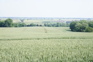 The typical agricultural landscape of the German JECAM site DEMMIN |
In Situ Observations
Survey at the landscape scale
- Crop Type(s): Winter Wheat, Canola
- Collection Protocol:
GFZ in-house protocol for regular sampling of vegetation and soil parameters on selected fields in the DEMMIN site
- Frequency: 11 days (March – October, 2012- 2019, 2022 planned to continue)
Survey at the field level
- Crop Type(s): Winter Wheat
- Collection Protocol:
With our students we collect spectral, vegetation and soil parameters during field campaigns in the vegetative phase of winter wheat. These campaigns analyse elementary sampling units with each 14 secondary sampling units in a 70 m x 70 m rectangle. The parameters include spectra and solar radiation information, LAI, SPAD, crop height, vegetation density, phenological phase, plant orientation, fresh and dry biomass, and soil moisture. A preview to our data can be found here.
- Frequency: Up to five sampling campaigns during the winter-wheat season (2018, 2019, 2021-ongoing)
EO Data
Optical Data Requirements
SAR Data Requirements
Passive Microwave Data Requirements
Thermal Data Requirements
Results
Documents and Files
Links to paper
- Löw, J.; Ullmann, T.; Conrad, C. The Impact of Phenological Developments on Interferometric and Polarimetric Crop Signatures Derived from Sentinel-1: Examples from the DEMMIN Study Site (Germany). Remote Sensing. 2021, 13, 2951.
https://doi.org/10.3390/rs13152951 - Vallentin, C., Harfenmeister, K., Itzerott, S., Kleinschmit, B., Conrad, C., Spengler, D. (2021): Suitability of satellite remote sensing data for yield estimation in northeast Germany. Precision Agriculture, 1-31.
https://doi.org/10.1007/s11119-021-09827-6 - Harfenmeister, K., Itzerott, S., Weltzien, C., Spengler, D. (2021): Agricultural Monitoring Using Polarimetric Decomposition Parameters of Sentinel-1 Data. – Remote Sensing, 13, 4, 575.
https://doi.org/10.3390/rs13040575 - Dhillon, M. S., Dahms, T., Kuebert-Flock, C., Borg, E., Conrad, C., & Ullmann, T. (2020). Modelling crop biomass from synthetic remote sensing time series: Example for the DEMMIN test site, Germany. Remote Sensing, 12(11).
https://doi.org/10.3390/rs12111819 - Hosseini, M., McNairn, H., Mitchell, S., Robertson, L. D., Davidson, A., Ahmadian, N., … Becker-Reshef, I. (2021). A Comparison between Support Vector Machine and Water Cloud Model for Estimating Crop Leaf Area Index. Remote Sensing, 13(7), 1348.
https://doi.org/10.3390/rs13071348 - Vallentin, C., Dobers, E. S., Itzerott, S., Kleinschmit, B., Spengler, D. (2020): Delineation of management zones with spatial data fusion and belief theory. – Precision Agriculture, 21, 802-830.
https://doi.org/10.1007/s11119-019-09696-0 - Ward, K., Chabrillat, S., Brell, M., Castaldi, F., Spengler, D., Förster, S. (2020): Mapping Soil Organic Carbon for Airborne and Simulated EnMAP Imagery Using the LUCAS Soil Database and a Local PLSR. – Remote Sensing, 12, 20, 3451.
https://doi.org/10.3390/rs12203451 - Ahmadian, N., Ullmann, T., Verrelst, J., Borg, E., Zölitz, R., & Conrad, C. (2019). Biomass Assessment of Agricultural Crops Using Multi-temporal Dual-Polarimetric TerraSAR-X Data. PFG – Journal of Photogrammetry, Remote Sensing and Geoinformation Science, 87(4).
https://doi.org/10.1007/s41064-019-00076-x - Harfenmeister, K., Spengler, D., Weltzien, C. (2019): Analyzing Temporal and Spatial Characteristics of Crop Parameters Using Sentinel-1 Backscatter Data. – Remote Sensing, 11, 13, 1569.
- Heupel, K., Spengler, D., & Itzerott, S. (2018). A Progressive Crop-Type Classification Using Multitemporal Remote Sensing Data and Phenological Information. PFG – Journal of Photogrammetry, Remote Sensing and Geoinformation Science, 86(2), 53–69.
https://doi.org/10.1007/s41064-018-0050-7 - Vallentin, C., Spengler, D., Itzerott, S., Kleinschmit, B. (2018): Automatic delineation algorithm for site-specific management zones based on satellite remote sensing data. – Precision Agriculture, 19, 4, 684-707.
https://doi.org/10.1007/s11119-017-9549-y - Dahms, T., Conrad, C., Dienesh, K.B., Schmidt, M. & Borg, E. (2017): Derivation of biophysical parameters from fused remote sensing data. 2017.- (Paper: TH3.L10.5). – IEEE International Geoscience and Remote Sensing Symposium (IGARSS), July 23–28, 2017, Fort Worth, Texas, USA, IEEE Paper; 4374-4377.
- Dahms, T., Seissiger, S., Conrad, C. & Borg, E. (2016): Modelling Biophysical Parameters of Maize Using LANDSAT 8 Time Series. – The International Archives of the Photogrammetry, Remote Sensing and Spatial Information Sciences, Volume XLI-B2, 2016 XXIII ISPRS Congress, 12–19 July, Prague, Czech Republic. 171-175, doi:10.5194/isprs-archives-XLI-B2-171-2016.
- Ahmadian, N., Borg, E., Roth, A., & Zölitz, R. (2016). Estimating the leaf area index of agricultural crops using multi-temporal dual-polarimetric TerraSAR-X data: A case study in north-eastern Germany. Photogrammetrie, Fernerkundung, Geoinformation, 2016(5–6), 301–317.
https://doi.org/10.1127/pfg/2016/0307
Project Reports
Study Team
Team Leader
06120 Halle (Saale)
Germany
Other Team Members