
Overview
- Crop identification and Crop Area Estimation
Crops types are discriminated using multitemporal NDVI data. A decision tree algorithm have been implemented for each year, we intend to develop a more general and robust method. Information about land cover type is required to parameterize the models used (ET, Biomass, etc.). - Crop Condition/StressOur main goal is to monitor crop consumption and irrigation requirements using the coupling of FAO-56 method and NDVI time series (see results section). Crop water budget is useful operational information at plot scale (farmers) and at perimeter scale (irrigation managers). This type of products is also a valuable input for watershed integrated modelling, aimed at basins scale management, including groundwater.Crop water stress is monitored using thermal image processing, and the results are aimed at being assimilated in the crop water budget model (PhD student).
- Soil Moisture
Soil moisture is the primary objective tackled using microwave data, relying on ground measurements for cal/val purpose. This type of information may also be input in the crop water budget model (A new PhD is currently on this topic by using Sentinel-1 and Sentinel-2 satellites data). - Yield Prediction and Forecasting
Based on NDVI relationships and vegetation model. - Crop Residue, Tillage and Crop Cover Mapping
We don’t study yet residues nor tillage (this will be done in 2017). Crop cover mapping is related to the first point.
Project Objectives
Mapping Agricultural Areas
Operational Implementation Plan
Scale
Land Cover
- Spatial Resolution:
- Temporal Resolution:
Estimating Crop Area
Operational Implementation Plan
Field size measurement
Estimating Crop Conditions
Operational Implementation Plan
Crop Conditions
- Drought
- Biological Stress
Estimation of Biophysical Variables
Operational Implementation Plan
Biophysical Variables
- Vegetation Indices (NDVI, EVI, SAVI, etc.)
- Biomass
- Residue and Tillage mapping
- Flux measurements
Forecasting Agricultural Variables
Operational Implementation Plan
Agricultural Variables (large scale)
- Yield
- Soil Moisture
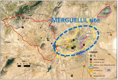
Site Description
| Landscape Topography | Alluvial plain |
|---|---|
| Typical Field Size | 1 to 4 ha |
| Climatic Zone | Subtropics, warm/ mod cool |
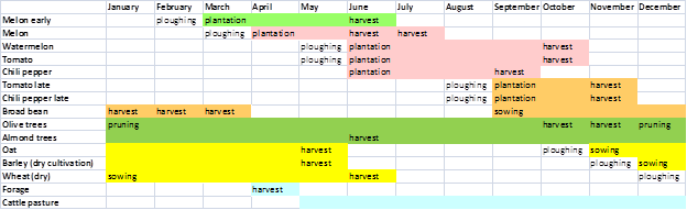
| Major Crops and Calendars | Cantaloupes and other melons (Early): Cantaloupes and other melons (Normal): Watermelons (Normal): Tomatoes (Normal): Chilies and peppers (Normal): Tomatoes (Late): Chilies and peppers (Late): Broad beans (Normal): Olives (Normal): Almonds (Normal): Oats (Normal): Barley: Wheat (Normal): Forage (Normal): |
| Soil Type & Texture | Inorganic:
|
| Soil Drainage Class | ["Well drained"] |
| Irrigation Infrastructure | ["Surface irrigation","Localized irrigation"] |
| Other Site Details |
Crop calendar:
|

In Situ Observations
Radiometric measurements
- Crop Type(s):
- Collection Protocol:
(CropScan : 16 bands VIS-MIR, including Landsat TM bands)
- Frequency:
Crop identification ground campaigns for land cover classification training
- Crop Type(s):
- Collection Protocol:
Data collected during three campaigns with about 150 plots observed each time
- Frequency:
LAI, fraction cover, biomass
- Crop Type(s):
- Collection Protocol:
Collected on annual crops and olive trees
- Frequency:
Temperature, Humidity, Wind Speed, Net Radiation, Rainfall
- Crop Type(s):
- Collection Protocol:
Three permanent meteorological stations
- Frequency:
Energy, Water, Carbon
- Crop Type(s):
- Collection Protocol:
Two Flux stations on irrigated wheat and rainfed olive orchard
- Frequency:
Area-averaged surface fluxes of sensible heat
- Crop Type(s):
- Collection Protocol:
One X-LAS scintillometer transect (1 km) starting spring 2013
- Frequency:
EO Data
Optical Data Requirements
SAR Data Requirements
Passive Microwave Data Requirements
Thermal Data Requirements
Results
Documents and Files
Links to paper
Project Reports
Study Team
Team Leader
Other Team Members